
As mentioned in the monthly summary, I had an unexpected offer to spend a couple of days in the Dolomites. Here’s the first part of that journey.
Continue readingCategory Archives: Travelling
May hiking part 1: Cold sun
At the beginning of May, I went for a 4-day hiking trip. As the title suggests, it was sunny, but with quite cold mornings.
Continue readingEuropean’s journey to the USA, part 1
As I mentioned in the monthly summary post, I traveled with my parents to see my Uncle in the USA in the second half of October. And there was a lot to see.
I’ve touched the flight there in the monthly summary. We landed shortly before midnight, so pretty much all we did after we reached him home was to go to sleep. That said, my usual curse – struggling a lot the first night in an unknown bed – made an impact and I was tossing and turning most of the night, eventually getting up feeling drowsy and tired the other day.
In the late morning, we went to the beach for a while, enjoying the warm day for a while, then we went shopping to be ready for the upcoming trip to the hills. Thus, a good part of the afternoon passed. By the end, we went to the USS North Carolina warship museum but arrived 10 minutes after the ticket office closed, so we just watched from outside and decided to return after our stay in the hills. Instead, we went for an ice cream (the scoops served there are HUGE compared to what’s common in my country) and, shortly after, returned to uncle’s home. I fell asleep shortly after and let my body catch up, waking up after 12 hours of sleep.
The second day, we were allowed to rest a bit more during the day – the plan for the evening was to see an ice hockey match, which involved a 2-hour drive from the shore. And I guess this was a good show of how the USA differs from my country. To mention a few things:
- Traffic. In Europe, there’s a lot of emphasis put on safe distance. The density of traffic on the highways in NC was just crazy and I still don’t understand how we managed to not see a single crash during the two weeks. Plus, Europe has a global 80 km/h limit for trucks (even if the road allows higher speeds for other vehicles), which isn’t the case in the USA so trucks were using just any lane instead of sticking to the right. Buses were nowhere to be seen, pretty much.
- Traffic signs. Those are much more… verbal, so to say, in the USA – a lot of them use words. In Europe, they’re just signs as much as possible – which makes sense as Europe is a continent of several languages.
- Churches. Not only it seemed like there are churches almost on every corner (and I honestly didn’t know there are so many branches of Christianity), but many of them would, at the first glance, look like an office building or a warehouse. Uncle told me it’s because of ease of construction. It still felt strange.
- Bread. Getting REAL bread (not the toaster excuse they call “bread”) isn’t easy in the USA.
- The Nothing. Europe is densely populated and it shows – if you take a highway, you’ll keep seeing towns and villages. Taking a highway in the USA often leads through endless miles with no permanent population in sight. I could say the same about the mountains – on some of the peaks we ascended, there was simply no village in sight.
Anyway, we departed quite early and, once we reached the stadium’s parking lot, several people – which included my uncle – had a portable grill and decided to make a BBQ right on the parking lot. Other families with kids were playing around, giving it a different atmosphere than is typical for events in my country. Also, things went very smoothly when entering the stadium, even with going through metal detectors (on a hockey stadium, of all places – that surprised me). Turns out the event organizers in my country are severely incompetent.

The atmosphere at the stadium was surprisingly sleepy. As far as I’ve heard, it was only the fourth match of the season, and it seemed like not just the players but also the fans were still getting warmed up, to the point it felt more like being in a theater rather than a sports match. Especially with nothing much happening in the first part. Once the goals started falling, the crowd became a bit more active, but it was still not nearly as passionate as football (soccer, if you’re American) matches here in Europe. At least the Hurricanes won.
The following day, we left the shore behind and traveled to the hills. With a few stops on the way to see a couple of friends of my uncle, we arrived in the hills shortly after sunset.
Early in the morning, we set out to see the sunrise on a nearby mountain. Getting there wasn’t easy – some roads were still facing the damage from the September storms and were either closed, or re-opened so recently the GPS still considered them closed, so we were weaving through narrow roads for quite a while. But, fortunately, we made it in time.

The colors just after the sunrise painted the landscape in a reddish tint that looked quite charming.

After finishing this short loop around the mountain, we returned to the chalet, though we stopped by one waterfall and a lake on the way.

Especially by the waterfall and the lake, the morning air was quite crisp – but the day eventually warmed up nicely. We departed for another shorter hike in the afternoon – this time, a location my uncle and my parents visited 10 years ago, but we took a bit different trail.

This trail led us to the waterfall above at first, then up to a nearby peak with quite a charming view and a palette of various plants growing on its slopes.


We then took a trail down the hills and intended to walk up the next hill but the trail was nowhere to be found in the dense shrubbery, so we took a detour using the lower trail. The steep wall of the mountain loomed above us though the forest often blocked the view.

After ascending the longer trail, we made it to the peak from the other side and enjoyed the view on one of the lookouts before making our way back to the parking lot, though the end was tricky as the trail in one area was also a bit too overgrown.

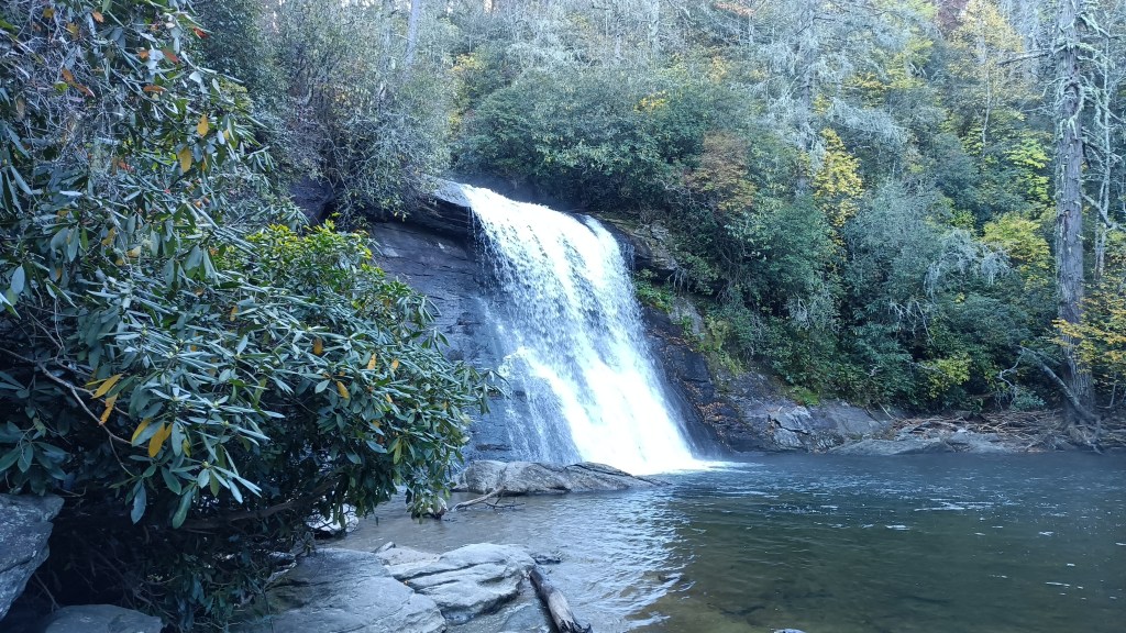
The second day in the hills turned out to be more a road trip than a hike I’d be used to – uncle improvised a fair bit on the go, taking us to some waterfalls that were along one of the mountain roads. Which was often quite a view as we folowed the Cullasaja river. The first was a relatively small waterfall right next to the road.

The second was a much larger waterfall (~20m) with three lookouts to see it from different angles and a footpath passing right behind it.


And just a short distance along the road was a set of smaller cascades.

Then, some distance down the road, we stopped by another waterfall. This one was a bit obscured by the foliage and the road passing above it, but we made our way closer on a tricky footpath to enjoy it from up close. The set of waterfalls is quite huge – as I looked it up, sources mention either 60 or 77 meters as the total height of the cascade.


We then spent quite some time on the road again, stopping in Cherokee for another waterfall.

On our way back to the main roads, we saw several reindeer massing around the visitor center and the surrounding area, some even chomping on foliage by the road.


Given that it was well into the afternoon of an autumn day, we decided to finish our day in the area and drive to the nearby mountain with a lookout. Taking the highway up the mountain pass was relatively smooth, but the parking lot at the mountain was quite crowded. Eventually, instead of waiting, we parked it at one of the nearby lookouts and walked the rest of the way to the parking lot and then the mountain itself.

The walk from the parking lot to the peak itself was gentle and easy – aside from small patches of snow and ice at the very peak – and the trail was quite crowded. Eventually, we decided to wait for the sunset. The temperature started dropping noticeably once the sun went down but that didn’t stop us – and there were many people around. As the sunset neared, more people with heavy-duty cameras gathered at the parking lot with a good view of the sunset, many planning to stay long into the night to take photos of the comet that could be seen during October. We eventually saw it as well before we left, but it was too faint for phone cameras.

I’ll wrap it up here for now and return to the rest of my journey in one of my next posts. There was still much to see, even with our options being quite limited by the recent storm.
A weekend in Slovakian Karst
The end of September had me go on a four-day trip to the Slovakian Karst area (and national park) – a place that seems quite a bit forgotten despite being the location of four UNESCO heritage caves.
Continue readingHiking: Sandstone and sandals pt.4
This post will be the last one depicting my week-long August holidays. The last two days still had a lot to see and I wasn’t willing to let anything just pass by if it was within reach, despite the piling fatigue.
Continue readingHiking: Sandstone and sandals pt.2
Last week, I covered the first two days of my week-long hiking trip. Let’s move on to the third and fourth days.
Continue readingHiking: August holiday pt.1
The previous Saturday (7.7.), I left for an 8-day hiking holiday. Over the next couple of weeks, I’ll be sharing some stories and photos from that time. Today, I start with the first two days.
Continue reading2019 hiking highlights
With 2019 coming to its end, it’s time to start looking back. Today, I’ll share my ‘best of’ from hiking.
Continue readingHow to be an eco-friendly hiker
I consider myself a friend of nature. With it comes an effort to leave as low impact on the nvironment during my travels as possible. Today, I’ll share some ways to be an eco-friendly hiker.
Continue reading2018 hiking highlights
With the year coming to a close, I am doing a “best of” highlight of this year’s hiking.

You must be logged in to post a comment.