
In this post, I’ll be sharing the story of the final days of my August hiking trip, which took a turn I didn’t expect. Unfortunately, a bitter turn, but more on that in a moment.
The fifth day
The fifth day was the return to the Valley of Five Lakes (and no, this wasn’t initially planned) I visited back in 2015. The trail this time was to be, in fact, quite similar – but that’s mostly because the two-pronged valley has only one entrance and two trails that connect the individual sides: upper and lower. Back in 2015, I had this hike as the last one and was fatigued, so I took the lower trail. This time, I planned to use the upper trail.

The early part of the trail is quite boring – a paved road that leads through the main valley and serves as a supply road for the chalet there (and a source of income for the locals – instead of walking, you can pay for a horse carriage ride).
The Valley of Five Lakes branches off roughly a third of the way, by the first waterfall. That one is tricky to take pictures of, as the bridge is crowded by many people trying to do the same.

At the crossing, I took the trail towards the lakes. The trail ascends slowly at first and keeps being quite light until it gets near the falls. The rain that bore on the hills for a week just before our holiday made for a much better sight than what I saw back in 2015…


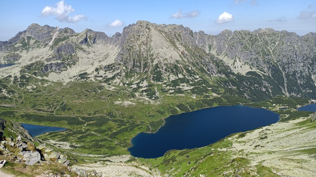
Above the falls, I took a break at the trail crossing near the largest lake. With a bright day ahead and a lot of time due to my fast pace through the valley, I intended to see all five lakes, which meant a short detour as the fifth lake is much higher in the valley.

During the following light ascension, I could see the largest lake and the front lake (closest to the mouth of the valley, at the back in the photo above).
When I reached the part where the upper trail across the ridge branches off, I considered my options for seeing the fifth lake. One was to take the official trail through the valley and turn at the point where I could see it. The other was to take another branch higher up – a trail that was removed. That failed because the turn became overgrown, despite higher portions of the trail being still visible.

The trail then started to ascend in quite an intense way, magnified by the warm and clear day. Finally, I had the fifth lake in sight. I took a photo, gazed down the valley for a moment, then turned to descend back to the crossing between the Large and Black lakes (the third and fourth) as well as the trail leading between them – the trail I was to ascend soon.


After a swift descent, I headed in the original direction. Shortly after I started ascending again, I caught up with the rest of my group (left behind in my dash to see the last lake).

As the trail zigzagged on the mountain’s slope and I rose above the valley, I could see the lower three lakes in their full beauty (though the aptly named Small Lake is barely visible between the Front and Large lakes).

At this point, given how the valley turns, I wondered if it’s even possible to see all five lakes at once – and came to the conclusion that, aside from flying, it might be tricky, but the peak I was heading toward could give me a chance. The final ascension had one a bit tricky passage, but since the chain was (for once) on the way up, I managed just fine.

The trail led me to the pass, from where it was only a short distance to the peak. Up there, I didn’t know where to look first. Eastward, towards the valley I was to use for descent, with its two large lakes?

Or maybe south? Another valley with two lakes, though one was hidden by a side ridge of the mountain.

Though, most of the time, the Five Lakes won. Unfortunately, without some extra-wide gear, I wasn’t able to fit them into a single photo in their full size.
I waited for the rest of my group so we could take a group photo, then started my descent, picking a calmer time on the sometimes quite busy trail. The descent gave me a chance to see the two lakes from a better angle…

…though none as magical as the look from the trail on the other side of the valley I walked back in 2015.

I planned to take a short stop to refresh myself at the chalet by the lower of the two lakes, but the place was way too crowded. I was lucky to find a place by the lake to sit down and change to sandals (which I carried the whole way) for the final part of the journey – 10km on the supply road, which is a test of resolve and endurance more than anything else, and made my feet hurt more than all the hiking so far combined.
The sixth day
The sixth day was to feature the last major peak of our trip. Even after five days of hard hiking, I didn’t feel any significant fatigue in my legs. I was looking forward to this trail mostly because of some level of overlap with one of the 2009 hikes, especially the two lakes. My main goal was the peak above the Green Lake.

With another warm, clear-sky day, I was hoping that the springs on the way wouldn’t be dry – and refilled my supply of water in one of them during the ascension through the woods.
When the woods opened up, we could see the same peaks we saw from the hotel, but from the opposite side.

As we were nearing the chalet, I noticed that my regular approach to eating during a hike was off: I had my first snack an hour later than usual. I dismissed this as a result of the hot weather – after all, I’ve known to have a lower appetite during hot days. In hindsight, this was the first hint of trouble – one I missed completely.
Shortly after the trail turned, we could see the chalet and the peaks above, though the lake was still hidden.

We took a short break at the chalet to rest and have some cool beverages. Then, we started the ascension. The trail gained altitude quite fast, and soon, we could see the chalet and the lake from above. The sound of a distant waterfall added to the scenery.

Almost halfway through the ascension, we took a short break at a tiny lake, which I also used to put on my helmet. Just above was another, even smaller, lake.


Instead of the typical zigzagging, the path ascended in quite a steady way, leading towards a chain-secured passage as the trail rose to the pass below the peak. I noticed a patch of flowers on the rock in addition to enjoying the scenery.

From the pass, the trail kept ascending towards the peak on a rocky terrain, where seeing the trail wasn’t always easy, but there were no passages steep enough to be equipped by chains. I was glad for that – there was only one way back down, the same I used to climb up.
As the days before, clouds clung to some of the hills. This time, some lighter clouds were scattered around the sky, partially shading us, even though it was barely noticeable.

As I waited for the others to catch up, I started to notice that something’s really wrong. My appetite was further decreasing (if there was any left) and I felt… strange, though I couldn’t exactly describe it or guess what the issue could be. I didn’t realize that, but looking at the photos, I can see in my expression (which is even worse in the group photo) that things were definitely going poorly.

Shortly after the photo, one of our group said she’d go ahead as she wanted to have some more time for the descent and that we should have no issue catching up – worst case, she’d wait for us at the chalet. I said that I was “feeling weird” and would rather have the descent done as soon as possible, so the two of us started together.
Even at the trickiest parts, I still felt that whatever’s coming might be simple indigestion and that it’ll pass. My goal was simple: get to the chalet without making things worse and take care of things there.

I even managed to enjoy the scenery during the descent towards the lake.

Back at the lake, the woman with me suggested a short break – she wanted to have something to eat. My appetite at that point was non-existent, and I was beginning to feel worse. Hoping for some relief, I used the lake’s cold water to cool down my head, to no avail. While she ate, I sat on a boulder and knew that the situation was becoming dire.
“I’ll need to take things slow, I feel like I’m going to throw up.” With a significant part of a rocky descent still ahead of us, this was becoming a major problem. “If things go poorly, I’ll take a shorter trail down.” At that point, I still had no doubts I would make it out of the hills, even if I headed for the nearest village over our designated pick-up point.
As we reached the chalet, I sat down on one of the benches, strategically near a dense bush, and hoped for things to calm down. I asked for a 10-minute break, saying that I’d take the shortest route after. She let me rest, only asking me how I was feeling after those 10 minutes. I shook my head. “I won’t make it.” I didn’t know if it would take 5 or 50 minutes, but I knew, by that point, that things would get ugly. She returned a moment later, saying that they’d take me inside so I wasn’t sitting in the heat and would call for help. Which, given the harsh mountain terrain, would take a while. In the meantime, the inevitable happened – but I won’t be going into the ugly details.
Warning: potentially sensitive details
The mountain rescue team reached the chalet maybe 30 minutes later. By that time, the others had caught up with me, and I had told them to go on, knowing that I wouldn’t be able to go with them. By that time, I was already shaking. Stabilizing me took a while – not only the rescue team had to sort out the various medical kits for what they were trying to find (and dump expired batches aside), my stressed body refused to cooperate in other ways – my veins decided to play hide and seek and hooking me up to the IV bags took several tries (further delayed by me running to throw up). During that time, I did my best to recall what led to my issues, though there wasn’t much to go on.
30 more minutes later, I was set up for transport. “Can you walk to the car?” I shrugged, they helped me up and led me from the chalet. After taking the exactly 10 stairs down, I threw up again.
“Okay, this won’t work. Call the chopper.” During the next 30 minutes, I sat on a bench and waited. If nothing else, things inside started to calm down – or maybe there was nothing left that could go out. Then, the mountain rescue handed me over to the emergency team. They helped me into the helicopter, handed me a set of headphones, and took me to the hospital. Given my state, I couldn’t really enjoy the mountains from a bird’s eye view.
Once it was my turn, they handed me over to a doctor, the emergency team handed over the notes the mountain rescue team made about my so-far treatment, and they asked me again about the last 24 hours, with focus on whether I could’ve possibly eaten something harmful, though I couldn’t recall anything. That, and if it was dinner or breakfast, someone else in the hotel would be sick as well, which wasn’t the case.
Then, they took several blood samples, checked my blood pressure and pulse, ran an EKG test (and maybe something else I forgot), and asked when was the last time I threw up. Then, the doctor concluded that the cause could be food poisoning, overheating, or a combination of both. I was then laid on a bed to wait for the test results. I used the time to message my mother back at the hotel about my situation (so far, she only had second-hand accounts from the rest of my group) and waited for the test results with a mention that if I didn’t throw up for a couple of hours, I’ll be released.
Around 20:00 (four hours since being airlifted from the chalet), I was back to the examination room – for another questioning as the doctors changed shifts at 19:00. After the new doctor went through all the notes while listening to my story, she said that as my situation was stabilized, I’ll be released. She urged me to take things easy and not go hiking again for at least two days. If I had any energy left, I would’ve laughed – I might be stubborn, especially when hiking but, as we say in my country, “even death can’t harvest a barren field”. In other words, I would be glad to make it to my room, given how totally drained I was. I was then given some guidelines on what to eat (or not) in the next 48 hours to let my body ease back into normal functioning. I took a taxi back to the hotel, messaging my mother that I’m on the way. With some help, I made it back to my room.
The next day, it rained. It definitely felt like a strange situation that the rain held up until the day I was unable to continue, but I wouldn’t complain. During breakfast (when I barely managed one slice of bread), I faced a barrage of “what happened” and “how are you feeling” from the rest of our group. I managed to get myself to read a bit in the afternoon, though I mostly just rested with my mind blank. The eighth, final, day was similar, and I pretty much just waited for the afternoon departure.
So, the end of my holiday wasn’t what I hoped for, but I guess it was a life lesson I needed – that hiking is not just about my legs, and I should take good care of the rest of my body. And that being exposed to direct sunlight high in the hills is much more intense than in the lowlands. Something better learned now because it’s a lesson I’ll need, given the visible effect of global warming in central Europe.
And that’s it for today, and for the story of my week-long trip that was cut short. In the coming days, I realized things that I could’ve done better, though it’s hard to guess if they would’ve helped. Either way, it’s a reminder to not dismiss the subtle warning my body gives me – and to not underestimate the weather when it’s way too nice.

What a situation, Tom. So glad to hear you’re all better now.
LikeLiked by 1 person
Pingback: Farewell, 2023… | Tomas - the wandering dreamer