
Continuing from my previous post, today, I’ll share photos and thoughts from the third and fourth days of my August hiking trip.
The third day
The third day was to be similar to the second one when it came to the hike, but warmer. Geographically, we started just one valley to the east compared to the second day. The goal, this time, wasn’t a peak, but a pass high in the hills. As the bus dropped us off, the trail marker read exactly 5 hours to the pass.

The first 15 minutes or so followed a solid road which then changed into an unpaved road as the valley split into two branches. With clear skies above, it was a pleasant day that was getting warm… maybe too fast. The trail soon left this road, taking a higher path above the valley – and we soon saw why: The valley’s bottom bore marks of severe water erosion and flood damage. While the stream right now seemed calm, the wide, rocky riverbed was a clear mark that the swelling river would tell a different story.
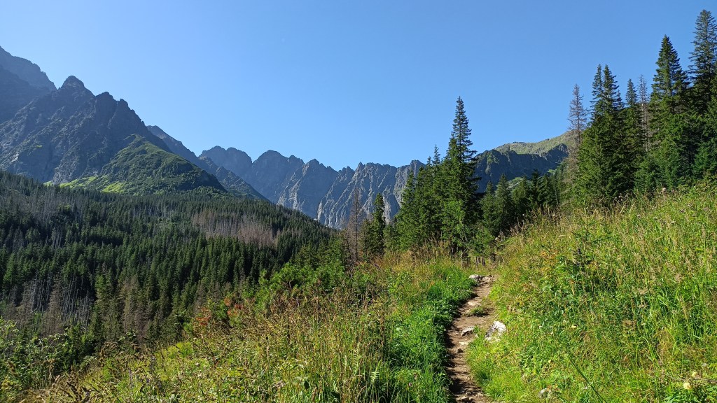
After some time, the trail got closer to the stream – well, one of its branches now that we were higher in the valley. I remained 5-10 minutes ahead of my friend (whom I considered unbeatable just a couple of years ago), proving that I was in peak condition for such a trip. He told me to wait for him at a footbridge.

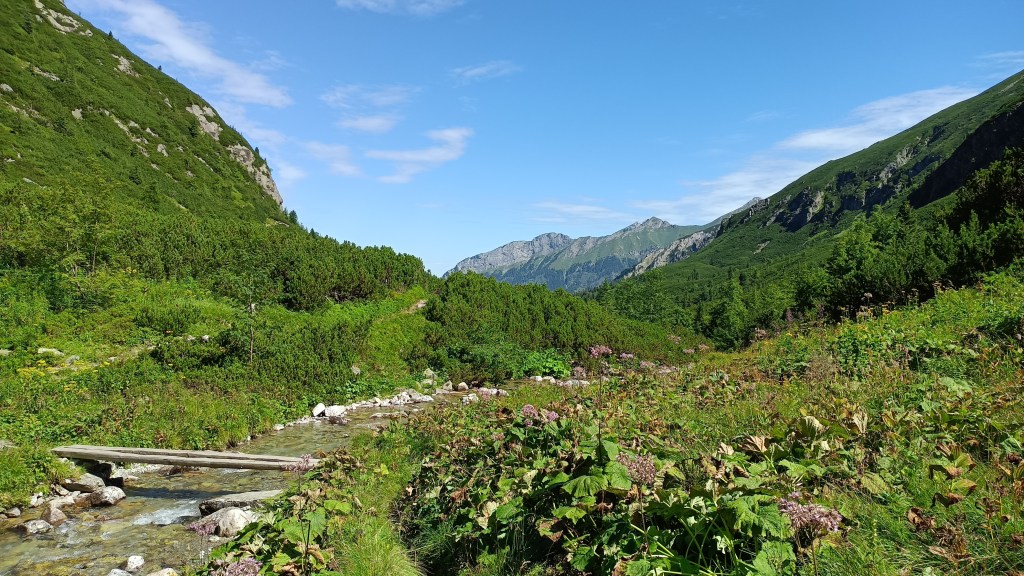
Once I reached the footbridge, I looked around as I waited. One of the slopes, overgrown with dwarf pine shrubs, had a gap in the grove, in which a thin waterfall hides.

We took a 30-minute break – I splashed myself with the cold water and washed the building sweat from my T-shirt. Then, we resumed the hike. Despite not feeling like my pace was any kind of fast, I soon had a noticeable lead.
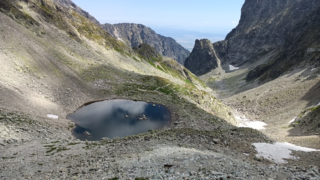
As I ascended, the grasslands gradually gave way to a sea of granite. Typical for the peaks, a small lake is nestled in the upper part of the valley.

I had a short 10-minute break as I waited for my friend to catch up, during which I used the stream to cool myself down again. At the highest portion with still any grass left, we saw another pack of chamois.

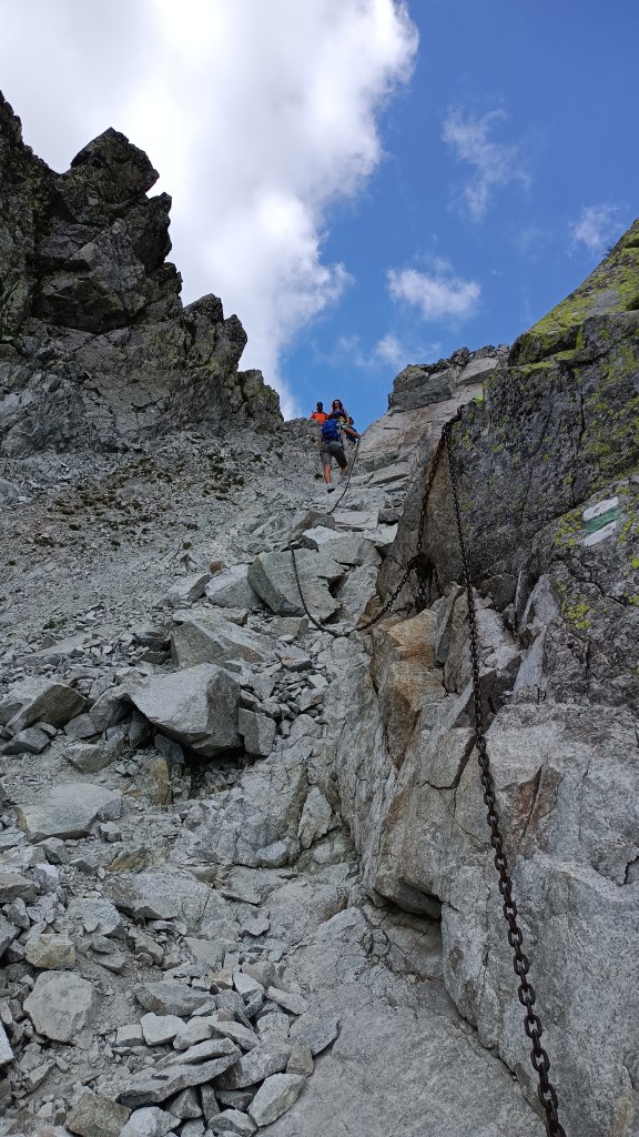
Gearing up for the final ascent (and putting on my helmet), I looked around a bit.

Similar to the previous two days, clouds still clung to some of the peaks, though they were fewer than the previous two days.

Despite one long break and two shorter ones, I reached the pass (at 2376m ASL) with more than an hour to spare. I wished that there was an official trail to the peak above, and while there was a footpath visible, my friend told me that reaching the peak involves some light climbing and getting up there and back to the pass would take up to two extra hours.
Looking down to the valley we were to descend gave little hint of what I knew to expect there: several lakes and a couple of waterfalls – on the lower plateaus of the valley.

As my friend wanted to take more rest, while I prefer to have at least an hour of lead – just in case – we split. The trail we chose for descent is much more frequented by hikers, so we knew neither of us would be helpless. And, once I reached the chalet further down the valley, it would be, in fact, quite crowded.
The initial descent was quite harsh: the first section secured by chains, and followed by zigzagging path through harsh terrain, visibly damaged by harsh mountain winters and boulders.
As this initial descent was quite harsh on the knees, I took a 5-minute break at the lake below, when the trail got more pleasant for the time being.
Then, I reached a crossing where another trail branches out – towards another hardly-passable pass. In the photo below, the trail I took is to the right, while the other branch is to the left.

Rounding the bend, the next plateau lay before me with its five lakes, though it was hard getting at least parts of three of them into a single photo.

While I was admiring the scenery, a loud sound took my attention: a helicopter. It made a pass above the lakes, sat down at the plateau by the chalet, and maybe five minutes later, it lifted off and left. I stopped for a couple of seconds to pay my respects to the hard work of the mountain rescue teams – while the hills might look charming in pictures, mistakes here can be dangerous or even fatal.
My stop at the chalet was brief – it was crowded outside, and the small space inside was one big bunch of people waiting in a queue that couldn’t even be called “line” to place their orders. So, I walked on. The trail takes an S-shaped detour as the valley drops down between plateaus.

As this set of turns is finished, it gives a view of the water taking the short way from the lakes above.


The trail then levels out for a while. It was during this section where I tried to pick up some speed, though it wasn’t easy, given how busy the trail was. The next chalet was undergoing repairs and, instead, there was only an outdoor stand with basic refreshments. I grabbed a cold cola to cool myself down and walked on, still pushing for speed if the situation allowed. Yet, by the time I reached the tall waterfall, it was over two hours since I started my descent…

This section of the trail is the one I mentioned in the prologue – where the stream was overflowing a mere week ago after some intense rain. Right now, despite the heat, there was a lot of water in the stream, and thus a lot to see in the waterfalls.
A short distance down the trail, I reached the lower falls. It was this part where the stream, in some parts, flooded the trail a week ago.


From there on, the rest of the trail was much more relaxed – most of the people visiting the falls took the trail towards the resort with easier access, while I took a side trail that’s much less busy, towards a smaller, more distant town. The woods were damp, still bearing traces of the intense rain from the previous week. I used that fact one more time to cool down with water from a small stream. This time, I didn’t have to look for an ice cream stand too long – it was right by the train station. With a bit of spare time, I sat down in the nearby park and read until our club bus arrived to pick us up.
The fourth day
The fourth day was “free for all” – a bus driver needs to have a set amount of work-free days. This gave three options: take a break (why would I do that?), take public transport to some other part of the hills (given the traffic jams due to road repairs – no, thanks), or take an easy hike near the hotel. In that aspect, suggestions were given ranging from 8 to 16km. Given that 16km is way too low for me, I looked at the map and decided to add a “bonus loop” that, by my rough guess, would be around 10km long and bring it to my usual length of around 26km. As I’ll share later, my math was both right and wrong at the same time.
Most of the people taking the hike took the easy way – taking a public bus to get rid of the walk through the village. I decided to avoid the inevitably crowded bus and walked – after taking the photo below right from the hotel’s balcony.

The early part was, due to the light terrain, a good way to ease into the fourth day. The trail did start ascending, eventually. By the time I reached the first peak, some of our people who took the bus and then the chair lift were already there. Having a lot of time, I decided to visit the treewalk lookout – as the name suggests, it features a trail at the treetop level and a lookout.

From the top of the lookout, I could see not just the mountains I’ve been visiting the previous three days, but also far in different directions and the lower hills around. One seemed to have an interesting rock formation, but it was way too far in the distance for a photo. It piqued my interest, though, and it could be an inspiration for another trip in the future.
The upper part of the ski resort with the lookout was also the start of my bonus loop, leading towards a lake hidden in the woods. Given the easier profile of the trail and the hot day, I decided to take sandals, which turned against me at that point – the trail in the shade of the wood was damp and I had to adjust my pace and walk style to not slip on the wet stone.
I expected the lake to be a flooded quarry by my glance at the map and its shape. The panel there told a different story – a short landslide created a natural dam and thus the lake.

I continued downhill. The stream leading from the lake created several tiny waterfalls (the tallest steps were 20-30 “tall” at most).

Thus, what caught my attention more was how the stream eroded the rock and soil and exposed the structure – almost level rock plates. Some of them quite long.

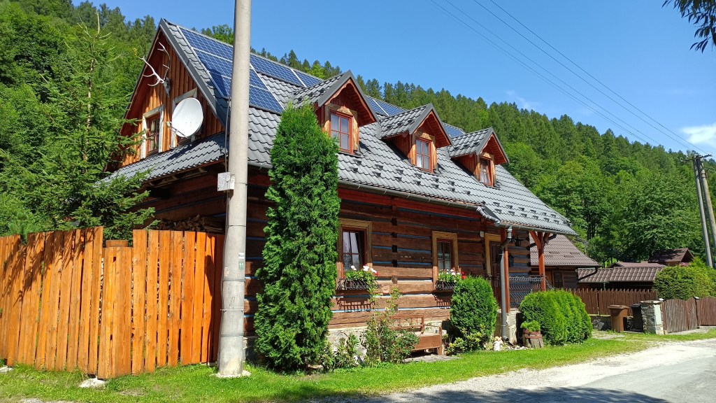
The trail led me to a small village with some traditional wooden houses, even if equipped with modern technology…
Reaching the end of the village in the other valley, I had to regain the lost altitude. Which was easier said than done – the trail was obviously used very sparingly. Tall grass on the mountain fields and dense undergrowth slowed down my progress in several places.
Thus, my 10-km bonus loop took almost three hours. I checked the distance walked so far – 22km – which gets me to why I was both right and wrong. The bonus loop was only a bit longer than I expected (11km instead of 10), but I forgot to remember that the 16km did count with using the bus and the chairlift, adding around 5km more to the equation. Thus, I was looking at a total length of over 30 km. With the day still nowhere near over (it was around 13:00) and at least two options to shorten it on the go, I decided to go on and see.
The next part was a sight I know from places closer to my home – a mountain plateau at elevation around 1200m ASL, deforested by a combination of drought and harsh winds that became the new norm for central Europe since the late 2000s (damn you, climate change).

I walked for around an hour on such a dry path – taking the full length. Near the end of this plateau section, I took a break in a chalet where I had a cold drink and an ice cream to help me deal with the heat. Then, it was time to turn back towards the hotel. The initial ascension was easy, across a field toward a lower pass (at 1000m ASL) with another ski resort right on the main road around the hills.

The resort had a couple of interesting wooden sculptures fitting the mountains. Some – like a shepherd with his dog – were realistic. Some were with a touch of creativity, such as anthropomorphized sheep and goat.

Then, the final descent to the valley, a long arc following the stream, and I was back at the hotel. The “free day” turned out to be the longest hike, though the easiest when it came to how steep it was (or, rather, wasn’t). Still, the heat had tested me a lot. And, in hindsight, it should’ve been a warning. For what reason? That’s something I’ll share in the next post when I get to share the final part of my holiday.
