
In this post, I’ll recall the first two hikes from my week-long hiking trip – a vacation that had a different ending than I hoped. But let’s begin with the beginning…
Prelude
I’ve spent a good part of June and July pushing myself quite hard to prepare for this trip (described in the recent posts), knowing that this will be a hard week. The hikes planned were to be long with significant elevation differences between the peaks and valleys. However, the June and July hikes had proven me more than ready.
The crucial element – weather – wasn’t a source of optimism at first. The beginning of August was rainy and the week before our departure was full of storms, to the point one of the well-known waterfalls was overflowing so much it flooded the trail. Fortunately, three days before my departure, it changed for the better. The mornings were still expected to be colder, but the days were to be sunny and quite warm.
I’ve also been to these peaks before – the southeastern part in 2009, the northern part in 2015, and the southwestern part in 2017. This trip was to fill in some gaps, especially from 2009, when my younger, untrained self couldn’t manage the hardest (and most beautiful) hikes yet.
Below, I share a map of the 2015 and 2017 hikes, missing the longest and hardest 2015 hike due to file corruption and the 2009 as I didn’t have a GPS back then.
Unfortunately, Google Maps has a limit on the number of layers in a single map, so I couldn’t add the 2023 hikes in the same map. This includes one June and one September hike in the area in addition to the 6 hikes from this trip.
The first day
The first day promised a chilly morning. Fortunately, it wasn’t as chilly as I expected – though walking to the station with two large backpacks to the station helped.
After a long bus drive, we neared the destination of the first hike. This one was more to the northwestern part of the hills, chosen to be on the way, to cover the remaining distance eastward to the hotel after the hike. As there were only a few major roads leading to the hills, and the one from our direction was undergoing repairs, we reached the starting point an hour later than the original plan.
To save a bit of time, I used the delay to pay the entry fee to the national park online rather than face a queue in a ticket booth, which was a smart decision. The initial part led through the main valley, and soon branched out to a side valley, ascending to a pass in the front row of the peaks. I’ve, in fact, used this section of the trail back in 2015.

Unlike the 2015 hike (when I kept to the front row), I took a turn towards the higher hills. The trail led mostly around the side of the peaks, with a gentle ascension at first – a good choice for the first day, I had to admit. Above the pass, it was shaded by the woods at first, and then it looped around one of the peaks in a way that provided a pleasant shade as well once we were above the woods.

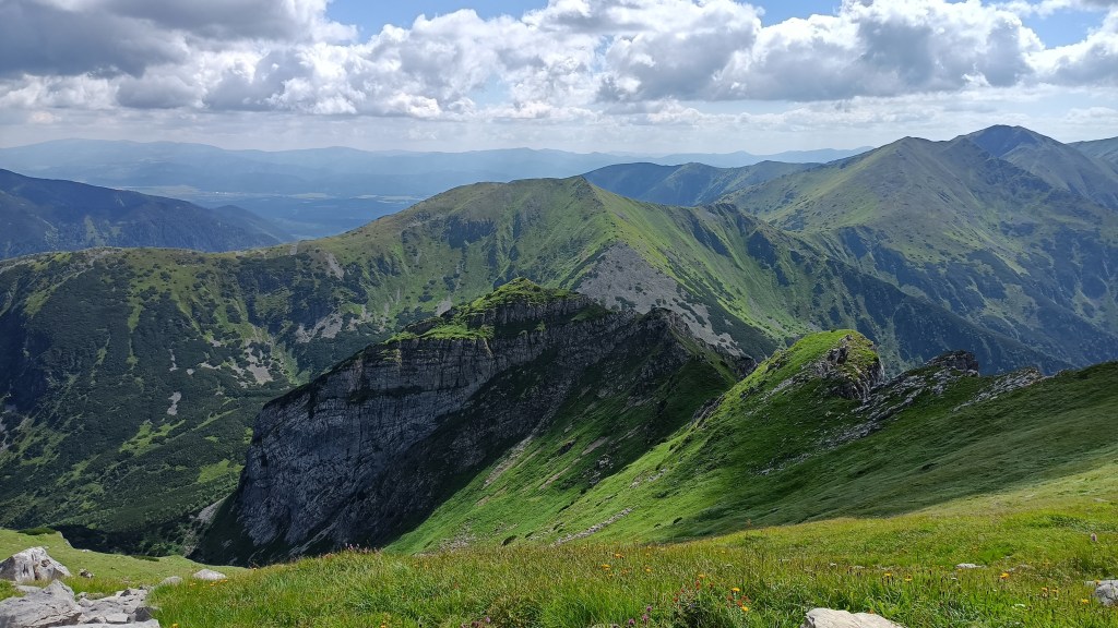
The scenery changed at that point – massive blocks of white stone jutting out of the hillside dominated the trail that was now taking a sharper ascension. In one tightly packed corner, the trail was secured with a chain to help with maybe a 10-meter section that ascended way too sharply to deal with without the use of one’s hands. This section wasn’t that hard uphill, but I can imagine it being quite tricky downhill. The grassy plains welcomed us with a light breeze and far sights as the trail tapered out once more.

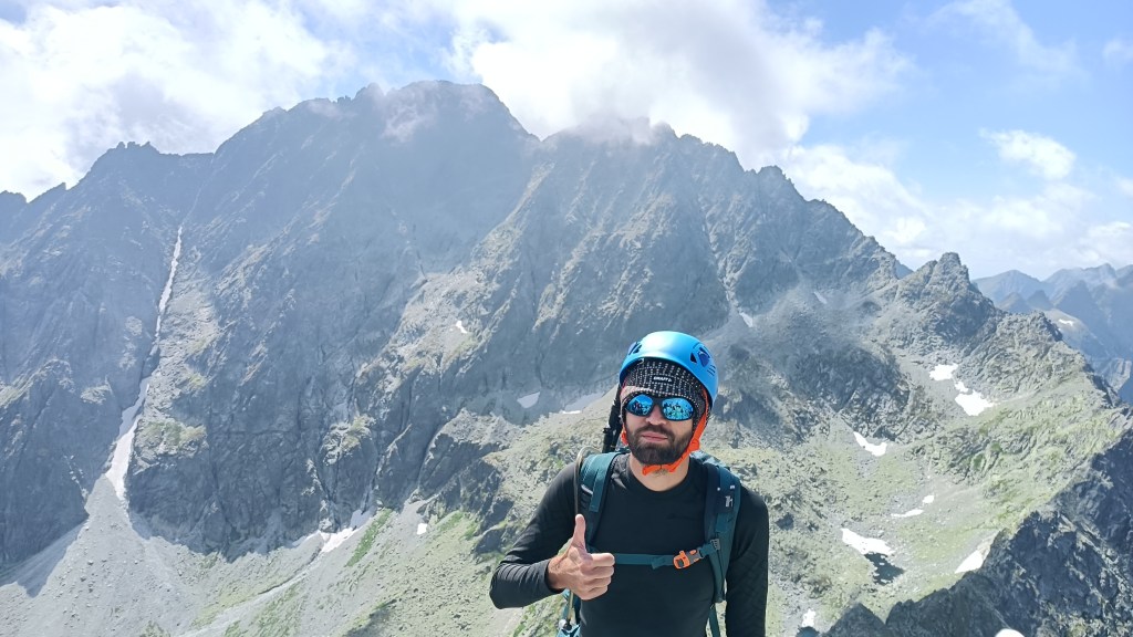
Upwards, the grass had a darker shade in the harsh mountain landscape, which explains why the three peaks are called the “red hills”.

At the peak, I took a break. In addition to many other hikers, there was another visitor at the peak…

After I (and most people around) took a couple of photos, the fox walked away a short distance with a bit of food one of the hikers gave it. I turned my attention towards the scenery around, gazing eastward, towards some of the peaks that were in my schedule for the next days, as well as reminiscing about the 2015 and 2017 journeys.

After all, I have a history with this place. Around one of the peaks, I had reached my 5000km hiked milestone back in 2015. And the valley that shapes much of the photo above is where I faced nasty leg cramps during a misty hike on the second day of the 2017 trip.
After my short break, I continued across the other two of the three red peaks, gazing at the grassy plains around, some of which I visited during the 2017 trip.
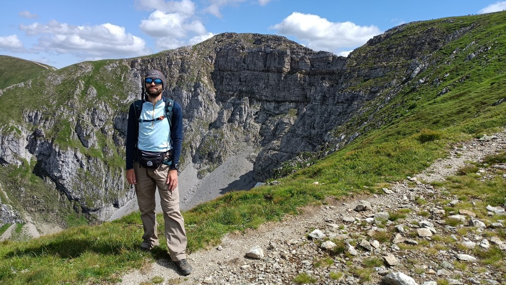
Given the delay, I decided to forego the extra loop around the mountain’s slopes during the descent and instead took a direct path. In the pass where the trails split, I posed for a photo showcasing the exposed cliff face on one side of the middle peak.
At this point, I was considering changing my T-shirt to something shorter and possibly shortening my pants, but decided against it, as it wasn’t that hot – not yet, at least, as the following days proved.
Anyway, the descent wasn’t as harsh as it can be in these hills, but it was still quite fast. I had a lot of elevation to lose, though – the peak behind me is 2122m tall, while the valley mouth is at 900m ASL. Roughly two-thirds through the descent, there was a quite nice-looking place with a solitary rock formation, though it was quite crowded.

I reached the valley mouth with a bit over an hour to spare, with many of the other hikes from our group (those who took a shorter trail) already present and enjoying the refreshments, though I had the opposite need. After fumbling with my wallet (which carried a mix of EUR and PLN), I managed to enter the toilets and occupy the only stall (seriously?) only to deal with some next-level frugal approach to energy savings – the light was controlled by a motion sensor and a 10-second (yes, seconds) timer. The sensor was aimed… I don’t know where, but not the, uh, throne. I wondered if a couple engaged in… procreative activities… would manage to keep the lights on, but doubted even that.
After we were all gathered, we boarded the bus to cross the remaining distance to the hotel. The short journey was supposed to take maybe 30 minutes, but we were out of luck – the shortest route was closed due to repairs and the detour was going really slow. To our shock, the jam was caused by a group of maybe five horse carriages, where their drivers decided to take the main road instead of the side streets.
We reached the hotel with a 70-minute delay. Given the late time and our growing hunger, most of us only dropped our backpacks in the rooms and rushed to the dining room like a pack of ravenous wolves. I guess to balance things out, we saw that the staff of the hotel can cook good food, which improved our mood sour from the delay.
But I took an early rest – to regain my energy, as the next day was to be one of the highlight hikes.
The second day
As the second day was to be similar in temperature to the first (a warm-up was expected to come after), the next hike was to the highest point of this trip. The hike started in a wide valley, giving us some time to warm up.

The valley was quite long, so it took around an hour before the trail started ascending a bit, by which time, peaks with steep slopes loomed above us.

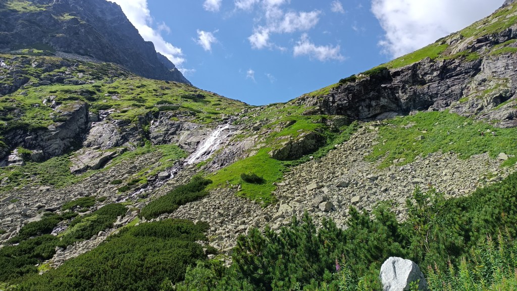
Around that time, the typical noise of a waterfall took my attention, though I was still in the shade of the woods, and it took a while longer before I could see it – a stream from one of the plateaus above dropping towards the valley. Unfortunately, due to the terrain configuration and the sunlight direction, I was unable to focus my phone on the relatively thin stream.
The trail kept ascending, turning from the valley toward the slopes, but still staying in the shade for the time being. Soon, a larger waterfall took our attention. Just as before, we could only admire it from a distance, but this one was larger and I managed to take a photo.

The upper valley provided us with a place fit for a short rest. With the day warming up, I saved my own supply and drank from the bubbling stream while enjoying the landscape around me.


As the trail ascended, we could see the plateau in the upper valley with the small lake, the stream from which feeds the waterfall.

The trail gave us little time to rest, though, as it kept ascending toward the third plateau. This, too, blessed us with the view of a lake that might look small at first glance, but it’s, in fact, around 160×160 meters large. The view standing right at the lake’s shore wasn’t that great, it was from above when the lake looked the best, with the peaks reflecting in the calm waters.

Even more so as we were nearing the next plateau.

And, yes, if someone is unsure about the white patches around, that’s snow. In some parts, especially the crevices that are shaded from the sun until the summer, it can last quite long, despite the fact the temperature in summer can go above 25°C (as was the case during my trip) – but make no mistake, even the summer can have cold waves – the damp week before my trip had, in fact, brought fresh snow to some parts of the hills, though it didn’t last a day.
Reaching the last plateau, we took a short break for a small snack just by the last lake, the Frozen lake, given that the valley holds snow and the lake’s surface holds ice into the early summer, sometimes even longer. The lake also has no source (being fully reliant on rain and snow) and the stream leaves it below the ground. We could also see the rocky path leading to the pass above.
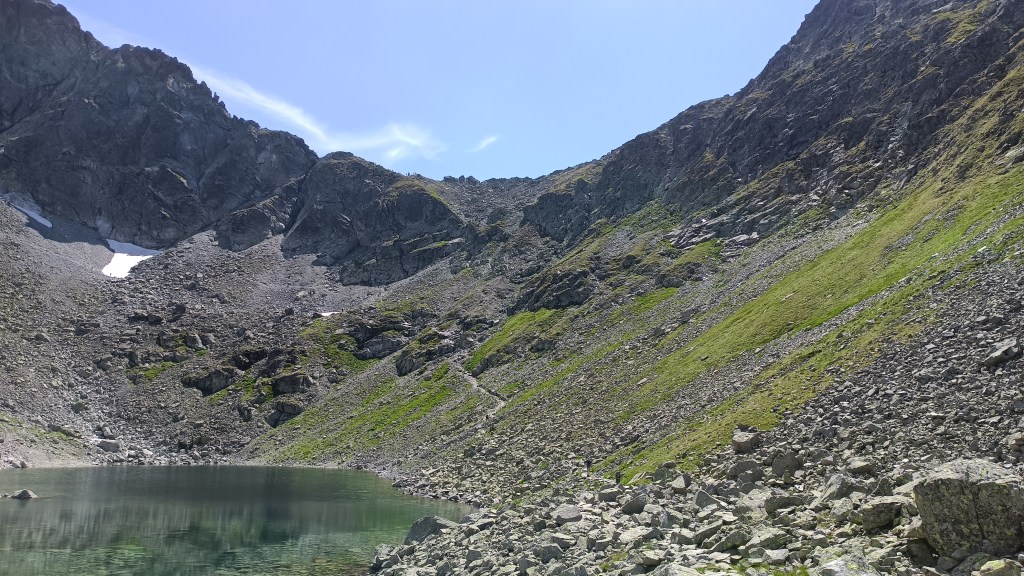
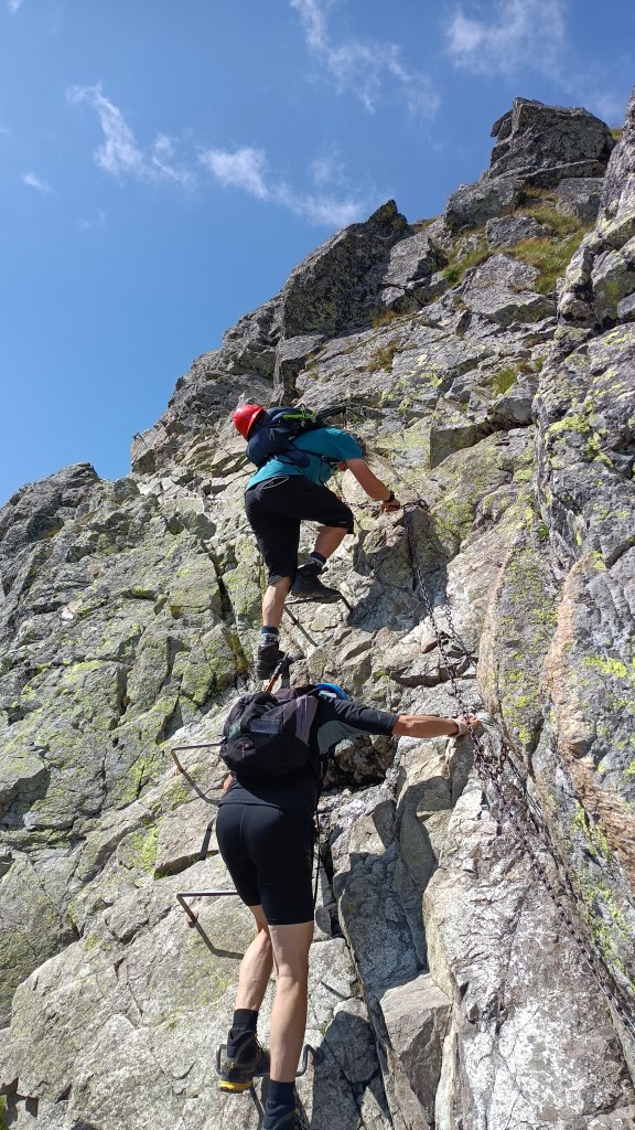
Due to an advisory issued for these higher, rocky portions, we put on helmets and, looking ridiculous, set out toward the pass. Once again, we often admired the lake from above – a view that shows well the lack of surface-level exit stream.

During the ascension, I also enjoyed the scenery around me. The trails split before the pass above, with one of the branches heading toward the east-bound peaks, crossing them in a tight gap I can hardly call a pass.

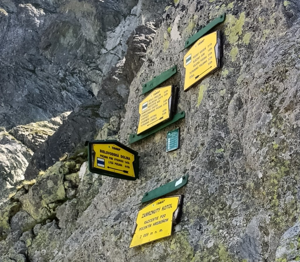
In such rocky terrain, providing directions is a challenge, and the trail markers were simply screwed into the rock face.
I took only a short break in the mountain pass to look at the surrounding peaks, then continued my ascension to the peak above. Some of the highest hills in the area were just across the valley (or two), the clouds coming and going, changing the scenery with every minute.

The ascension wasn’t as long as I expected, even with some parts being tricky and it sometimes felt more like crawling than hiking as I used all four limbs to progress. Which, honestly, isn’t that hard uphill.

The peak provided a 360-degree view of several mountains and valleys. Unfortunately, the peak itself provided very little space, and it was already quite crowded. Even then, I took several photos, and had a photo taken with the highest peaks behind me and trying to strike a pose like I knew what I was doing. And to demonstrate how silly I look in a helmet, but safety first. The idea of being hit by a pebble isn’t peasant.
After one more look towards the valley and lakes below, I started my descent back to the upper pass.

This took a bit longer than the ascension, having to deal with the tricky terrain during the descent, but I managed just fine (partially because it was only the second day and I was still quite fresh). The worst section was just below the pass, with some steep and exposed passages.
Soon after that, the trail eased up and we could resume normal walking (and take our helmets off once we were out of the rocky parts). Once some grass found its way to exist between the boulders, we also saw several chamois grazing and walking around, not caring at all for the bunch of dumb humans who walked the hills with no decent reason whatsoever.

Taking a photo of these nimble mountain goats is always tricky because they can move quite fast and blend in with the terrain.

Continuing with our descent, we neared the end of the upper plateau, giving us a view of the lake and hotel below.

The trail then weaves around a bit, passing under a rocky overhang called “neverending rain” as it constantly drips water. The stream takes a more direct route, sliding across the exposed rock towards the lake.
From a distance, especially the hotel, you can’t really notice it’s not a true waterfall.

I took a photo from the closer end of the lake (above) and the farther end (below).

From the hotel, the trail dropped back into the woods after several hours in the sun. During the (mostly) gentle descent towards the nearby town, I picked up speed to give myself a bit of time to rest once I was done and maybe find an ice cream stand (which I managed near the train station). Thus ended the second day, with more to come, but that’s a topic for the next post some other day.
So, that’s about the first two days of my 2023 hiking trip. Both days had left me pleasantly exhausted but still longing for more, and I was determined to get it, especially with the promise of good weather.

Pingback: August hiking holiday, part two | Tomas - the wandering dreamer